Routes

Valtellina
Trekking

Cólmen of Dazio: a mediterranean oasis in the heart of the Alps

DIFFICULTY: E
DISTANCE/LENGTH: 5.7 km
ELEVATION GAIN: 390 m
DURATION: 2 hours 30 minutes
BEST TIME TO VISIT: All year round
RECOMMENDED STARTING POINT: Dazio, Cemetery
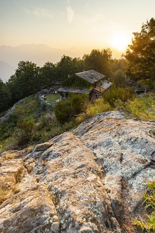
From the parking area near the cemetery in Dazio (557 m a.s.l.), take the dirt road on the left that leads through wide meadows toward La Cólmen (trail markers red and white, no. 5). The route climbs steadily through the woods, passing through the area known as Crotto on its way to the summit.
Before reaching the top, near some rocky outcrops by a curve in the trail, you’ll be treated to a superb view over the central Valtellina, stretching as far as Sondrio and beyond. At the summit (921 m a.s.l.), sun-dappled clearings among shady groves offer a perfect spot to rest. The panoramic views continue at the La Casermetta refuge, located right on the peak and named after a former military lookout post built during World War I.
For the return, follow the mountain ridge westward (trail no. 8), where you’ll pass several small seasonal ponds—essential watering spots for the many deer inhabiting the protected Cólmen area. From the locality of Böcc, marked by the excavation tunnels of ancient iron mines, take trail no. 6 down the northern slope of the mountain back to the village.

Routes

Valtellina
Trekking

Along the ridge between Alpe Granda and San Cères

DIFFICULTY: E
DISTANCE/LENGTH: 9.7 km
ELEVATION GAIN: 850 m
DURATION: 3 hours
BEST TIME TO VISIT: From May to October, and in winter with snow
RECOMMENDED STARTING POINT: Dazio, Cemetery

Between the two mountain pastures of Our di Fondo and Our di Cima, a dirt road begins that, in about an hour, leads to the scenic grassy balcony of Alpe Granda. Leaving the small hill of Cima di Granda on the left, turn right and climb the pasture to reach the new Alpe Granda refuge (1,688 m a.s.l.).
A trail enters the forest, passing through Alpe Merla and then, after two switchbacks, reaches the central section of the broad Scermendone pasture. This lies along the ridge separating Valtellina from the eastern side of Valmasino. From here, enjoy a spectacular panorama: to the south, the Orobic Alps and much of Valtellina; to the north, the towering peaks of Valmasino; to the east, Monte Disgrazia; and to the west, the mountains of the Costiera dei Cèch.
After passing a small lake near a mountain hut, continue along the ridge to the final destination: the ancient church of San Quirico, locally known as San Cères (2,131 m a.s.l.).
The return route follows the same trail.

Routes

Valtellina
Trekking

Lake Palù: a sapphire jewel in the heart of Valmalenco

DIFFICULTY: E
DISTANCE/LENGTH: 8.5 km
ELEVATION GAIN: 440 m
DURATION: 3 hours
BEST TIME TO VISIT: From May to October, and in winter with snow
RECOMMENDED STARTING POINT: Chiesa Valmalenco, San Giuseppe

Near the parking area by the San Giuseppe chairlift, take the dirt road that begins at the bridge. After a few switchbacks through conifer forests, you’ll reach the locality of Barchi, where the path turns into a trail, briefly running alongside what becomes a ski slope in winter.
Turning left, you leave the wide slope and zigzag through the forest. As the slope gradually lessens, you’ll arrive at your destination. Suddenly, the lake appears (1,921 m a.s.l.), rewarding all effort with its stunning beauty—perfect for a refreshing swim in the warmer months.
Don’t miss the unmatched views from the Palù refuge, on the left-hand side of the lake as you approach. A half-hour walk along the lake’s edge offers breathtaking vistas.
For the return, you can retrace the same route or take an alternate trail that begins to the right, just below the refuge. It winds through the woods and the localities of La Zocca, Il Barchetto, and Paluetto. Continuing left from this scenic meadow basin, you’ll soon reconnect with the original path.

Routes

Valtellina
Trekking

Alpe Prabello and the Campagneda Alpine Lakes

DIFFICULTY: E
DISTANCE/LENGTH: 10.1 km
ELEVATION GAIN: 430 m
DURATION: 3 hours
BEST TIME TO VISIT: From May to October, and in winter with snow
RECOMMENDED STARTING POINT: Lanzada, Campo Moro

From the large parking area at Campo Moro, near the Zoia refuge (2,021 m a.s.l.), take the trail next to the refuge that skirts the southern side of Mount Spundascia. This mountain overlooks both the artificial lake on one side and the wide Campagneda valley on the other.
Passing rock faces polished by glaciers—now equipped for climbing—you’ll soon reach Alpe Campagneda. From here, following the signs and crossing a small stream in the valley bottom, it takes just over half an hour to arrive at the enchanting Alpe Prabello (2,226 m a.s.l.), nestled beneath the majestic peak of Pizzo Scalino.
The return follows the same route; however, more energetic hikers can take a circular route by continuing up to the Campagneda alpine lakes (the first at 2,279 m a.s.l.) and descending via the main valley to rejoin the original trail near the Alpe Campagneda refuges.
The route is also recommended for mountain bikers, who can start from the parking area located just over a kilometer before Campo Moro, at the beginning of the dirt road.