Routes

Sentiero Valtellina da Colico a Morbegno
Cicloturismo

Following the tracks of the historic Ganda Bridge

DIFFICULTY: Low
SAFETY LEVEL: High
DISTANCE: 25 km
ELEVATION GAIN: 200 m
SURFACE: 90% asphalt, 10% dirt
TYPE: Touring
TIME REQUIRED: 1.5 hours
BEST TIME TO VISIT: All year round
RECOMMENDED STARTING POINT: Colico

Ciclotip

Before heading out, check the weather: it can change quickly in the summer.

The perfect spot for a delicious break

Eden il ristorante della pizza

Via Bernasconi, 60 – 23013
Cosio Valtellino, fraz. Regoledo (SO)

T +39 0342 635769
E info@ristorantepizzeriaeden.com
W ristorantepizzeriaeden.com
FB /Edenmorbegno
IG @edenilristorantedellapizza

Suggested sandwich

Leavened dough disc, light, thin, and crispy, folded to form two lips, filled with Bresaola della Valtellina PGI, fiordilatte cheese, iceberg lettuce, and Greek yogurt.

The Sentiero Valtellina is a 114 km pedestrian and cycle path that begins at Lake Como (Colico) and runs through the Adda River valley, ending in Bormio, in Upper Valtellina. It’s a long, mostly flat, green route flanked by the Rhaetian Alps, with their iconic terraced vineyards, and the Orobic Alps, ideal for families and largely reserved for cyclists.

Starting from Colico’s small port, the trail follows the lakeshore on a cycle path—partly with compact dirt or grassy surfaces—until it reaches the Adda River near Ontano beach. Here, the first 2.5 km are unpaved, but the trail then becomes entirely asphalted.

Along the way, you’ll pass through small woods and open fields, with plenty of scenic rest areas perfect for a tasty picnic. Reaching Morbegno, you’ll come near the Ganda Bridge, built in 1776, which links the towns of Morbegno and Civo—a great spot to take a memorable photo. From here, you can continue your journey or stop to explore the charming town of Morbegno.

This ride allows you to discover the natural and cultural beauty of Valtellina at a slow pace, including picturesque villages and landscapes. In Cosio Valtellino, don’t miss the 250-meter pump track in the Sarach area, a modern feature in a 2,500 m² green zone.

For a delicious break, we recommend stopping at Eden – Il Ristorante della Pizza in Cosio Valtellino, where you can enjoy a variety of dishes, including one made with the renowned Bresaola della Valtellina.
Routes

Ciclo tour verso la Val Tartano
Cicloturismo

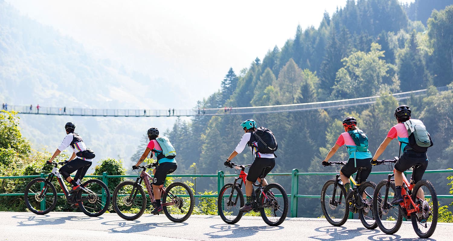
A sky bridge among the highest in Europe

Difficulty: Medium
Safety Level: Low
Distance/Length: 43 km
Elevation Gain: 1,200 m
Road Surface: 95% asphalt, 5% dirt
Technique: Recreational
Estimated Time: 4 hours
Best Period: From May to October
Recommended Starting Point: Morbegno

Ciclotip

Bring a snack and water: especially in the heat, staying hydrated is essential.

The perfect spot for a delicious break

Albergo Ristorante Vallunga

Via Roma, 12
23010 – Tartano (SO)

T +39 0342 645010-645100
E vallunga.tartano@libero.it
W hotelvallunga.it
FB /albergovallunga

Suggested sandwich

Rye bread, Bresaola della Valtellina PGI, semi-fat cheese from Val Tartano, mayonnaise, lamb’s lettuce.

The cycling tour to Val Tartano is a beautiful itinerary that, due to its length and elevation, requires moderate fitness or, at most, an e-bike. Among other highlights, it allows you to admire one of the wonders of Lower Valtellina: the suspension bridge connecting Campo Tartano and Frasnino. This 234-meter-long bridge is suspended 140 meters above the Tartano stream. Built in 2018 and made up of 700 wooden planks, the structure and the entire route are breathtakingly beautiful.

Starting from the village of Morbegno, head towards the Ganda bridge. Crossing it, take the Sentiero Valtellina on the right and follow it until you reach the provincial road. To the right, you’ll find a single-lane bridge to cross. From there, via an underpass, you will come out onto Viale Stelvio, where the road is busier and requires extra caution.

After about 2 km, you’ll reach a roundabout—take the exit towards Tartano. Follow the road for 1 km until you find a fork on the right leading to Val Tartano. From here, climb about 10 km on a scenic road with small glimpses of the valley until you reach Campo Tartano, where you can finally relax and enjoy the view of the stunning Ponte nel Cielo (Bridge in the Sky).

Next, you can continue along the road towards Tartano, where at Albergo Ristorante Vallunga you can refresh yourself with an excellent sandwich made with Bresaola della Valtellina and rest. After the break, descend following the same route back to Morbegno.

Routes

Anello degli Andossi di Madesimo
Cicloturismo

A charming plateau with a lake view

Difficulty: Low
Safety Level: High
Distance/Length: 21 km
Elevation Gain: 660 m
Road Surface: 20% asphalt, 80% dirt roads
Technique: For skilled cycle-hikers
Estimated Time: 1h 40min
Best Period: From May to October
Recommended Starting Point: Madesimo

Ciclotip

Wear your helmet: using your head means protecting it.

The perfect spot for a delicious break

DallAle Bistrot

Via Antonio De Giacomi, 5
23024 – Madesimo (SO)

T +39 335 5727958
E dallalebistrot@gmail.com
FB /dallalebistrot
IG @dallalebistrot

Suggested sandwich

Five-grain bread, Bresaola della Valtellina PGI, Sardinian pecorino cheese, cherry tomatoes, Bistrot sauce.

The 21 km loop route unfolds on beautiful white dirt roads across the Andossi plateau, starting and ending in Madesimo. The landscape is stunning, offering magnificent views of the peaks of Valle Spluga: Pizzo Stella, Groppera, Emet, Suretta, Tambò, Ferrè, and Quadro.

From Madesimo, take Via Giosuè Carducci in the town center, then continue on Via Emet. After passing near a heliport, turn right towards the hamlet of Zerbi. You’ll find a lovely dirt road leading for 400 meters, which reconnects with Via Emet. Continue straight for another 400 meters, then either stop to visit the “Buco Blu,” a pond with a strikingly vibrant color, or turn left onto the path marked “Tec dal Luzi.”

Follow this route until you reach the paved road, then turn right into a small alley leading to a river crossing via a footbridge. From there, climb up a dirt road and continue to the right until you reach the Andossi Plateau. At this point, you can either follow the 5 km loop trail to the right, or descend to the left toward Lago di Montespluga and cross the plateau in the opposite direction.

From here, you’ll enjoy breathtaking valley views, discover the stunning Lago degli Andossi, and—looking up—admire the spectacular Valcava Alpine Garden. After a well-deserved break, descend back to Madesimo either via the same road taken earlier or via alpine trails suitable only for the most experienced cyclists.

Once back in the village, be sure to try a specially crafted sandwich at the renowned DallAle Bistrot, located in the heart of Madesimo.

Routes

Ciclabile della Valchiavenna
Cicloturismo

In the Heart of the Crotti of Tanno

Difficulty: Low
Safety Level: Medium
Distance/Length: 45 km (90 km for the full loop)
Elevation Gain: 900 m
Road Surface: 70% asphalt, 30% dirt roads
Technique: Touring
Estimated Time: 3 h (6 h for the full loop)
Best Period: All year round
Recommended Starting Point: Colico

Ciclotip

Plan every outing in detail: let the only surprise be the view.

The perfect spot for a delicious break

Il Locale Risto-Crotto-Bar

Viale Pratogiano, 16b
23022 – Chiavenna (SO)

T +39 0343 34343
E info@hotelcrimea.net
W hotelcrimea.net
FB /IlLocaleChiavenna
IG @il_locale_chiavenna

Suggested sandwich

Polenta-flour focaccina with Bresaola della Valtellina mousse, artichoke and almond pesto, crispy Bitto cheese wafer, and confit cardoncelli mushrooms.

The Valchiavenna Cycle Path (3rd place winner at the Italian Green Road Awards 2022) is a scenic valley-floor route starting in Colico and reaching the Swiss border. Stretching 40 km, it takes you up the valley to Chiavenna, renowned for its crotti—traditional taverns where you can enjoy local specialties.

From Colico, head toward Sondrio along a beautiful dirt path running by the lake, then veer toward the Adda River. At an overpass, leave the bike path, cross to the opposite side of the river, and turn left to enter the famous Pian di Spagna Nature Reserve. A lovely unpaved road leads you to the roundabout before the Passo Bridge. From there, continue toward Chiavenna for 600 meters, turn right, and ride for 1 km within the reserve.

Once out, continue toward Bocca d’Adda. Before the railroad crossing on the right, rejoin the cycle path that follows the lakeshore of Novate Mezzola, filled with scenic views—perfect for a snack or a rest.

Continue on the path until you reach Chiavenna. After the sports field, cross to the opposite bank of the Mera River, cross the main road, and take Via Strada di Tanno, heading straight until you reach the Crotti of Tanno. After the first right-hand hairpin turn, a bike path to the left brings you back into the town center, where Il Locale Risto-crotto-bar is a great stop for a snack featuring Bresaola della Valtellina.

From there, head toward Piazza Castello, take a small street to the left of Palazzo Balbiani, and reconnect with the cycle path leading to the Swiss border. A slight detour will take you to the Acquafraggia Waterfalls in Piuro, a well-known gem of the valley

Routes

Tour ai laghi di Cancano
Cicloturismo

Due specchi d'acqua turchese a 1.950 metri

DIFFICOLTÀ Bassa
LIVELLO SICUREZZA Alto
DISTANZA/LUNGHEZZA 20 km
DISLIVELLO 227 m
FONDO STRADALE 15% asfalto, 85% sterrato
TECNICA Turistica
TEMPO DI PERCORRENZA 2 ore
PERIODO MIGLIORE Da maggio a ottobre
PUNTO DI PARTENZA CONSIGLIATO Torri di Fraele, Valdidentro

Ciclotip

Promuovi il territorio e rispettalo: sei suo ospite.

The perfect spot for a delicious break

Ristoro Monte Scale

Località Cancano
23038 – Valdidendro (SO)

T +390342904660
E ristmontescale@libero.it
W cancano.com
FB /ristoromontescale

Suggested sandwich

Pane di segale, Bresaola della Valtellina, crema di avocado, Scimudin, pomodoro fresco, rucola.

I laghi di Cancano e di San Giacomo di Fraele sono due bacini artificiali situati a quasi duemila metri di altitudine nella Valle di Fraele, nel Parco Nazionale dello Stelvio, non molto lontano da Livigno e Bormio. Due splendidi specchi d’acqua che non smettono di incantare i turisti.

Partendo dalle torri di Fraele, in sella alla nostra bici costeggiamo il lago delle Scale per raggiungere la prima diga, dove ci fermiamo ad ammirare lo splendido panorama sul lago di Cancano (la diga, realizzata tra il 1953 e il 1956, riceve le acque di svaso della diga di San Giacomo e del canale Viola). Da qui è possibile proseguire fino alla bella chiesa di S. Erasmo, la cui struttura in pietra richiama la silhouette della montagna che la incornicia.

La strada, ampia e pianeggiante, costeggia le sponde del lago sul lato sinistro fino a raggiungere il lago di San Giacomo di Fraele. Attraversiamo la diga che divide i due laghi (risalente al 1940 ma conclusa nel 1950 a causa degli eventi bellici, è alimentata dal canale dello Spöl, i torrenti Alpe, Gavia, Frodolfo, Zebrù, Braulio, Forcola e parte del fiume Adda) e procediamo fino alla romantica chiesetta di San Giacomo. Consigliamo una sosta nelle aree picnic, per ammirare al meglio il lago e rinfrescarsi alla fontanella.

Poco più avanti troveremo un’altra area picnic attrezzata. Da qui, potremo proseguire il tour su una bellissima sterrata che ci riporterà al punto di partenza. Infine, per una ricarica di energia lungo il percorso, vi consigliamo il Ristoro Monte Scale .

Routes

Ciclabile sentiero Frodolfo e sentiero Viola direzione Planecc
Cicloturismo

In the beauty of Bormio, with the whole family

Difficulty: Low
Safety Level: High
Distance/Length: 5 km
Elevation Gain: 100 m
Road Surface: 98% asphalt, 2% dirt road
Technique: Touring
Estimated Time: 45 minutes
Best Period: From May to October
Recommended Starting Point: Bormio

Ciclotip

Always help those in difficulty: your support could save a life.

The perfect spot for a delicious break

Il Bistrot Bormio Terme

Via Stelvio, 14
23032 – Bormio (SO)

T +39 0342 901325
E info@bormioterme.it
W bormioterme.it
FB /BormioTerme
IG @bormioterme

Suggested sandwich

Rye bread with Bresaola della Valtellina PGI, avocado cream, Scimudin cheese, fresh tomato, and arugula.

We’re in Bormio, a renowned summer and winter tourist destination located in the Stelvio National Park. This route follows the cycle and pedestrian path, allowing for a relaxing and safe ride—perfect for families.

Starting from the Tourist Office, head toward the Frodolfo stream and follow the dedicated path along Via Italo Occhi. Continue on this track until you reach S. Lucia, where you briefly join the Sentiero Valtellina, running alongside the Adda River heading north toward the hamlet of Premadio.

On your left, after crossing a charming wooden bridge, a short dirt path leads to Planecc, a recreational area perfect for a picnic and a break with kids. Returning to the wooden bridge and rejoining the cycle path, you’ll reach the Church of San Gallo, known for its distinctive bell tower.

From there, ride back toward Bormio along the edge of the golf course, finishing at Bistrot Bormio Terme, where you can enjoy a well-deserved meal featuring Bresaola della Valtellina.

Routes

Sentiero Valtellina da Tirano a Grosio
Cicloturismo

An ancient story among rock engravings and castles

Difficulty: Very Low
Safety Level: Very High
Distance/Length: 16 km
Elevation Gain: 200 m
Road Surface: 90% asphalt, 10% dirt road
Technique: Touring
Estimated Time: 1.5 hours
Best Period: From April to November
Recommended Starting Point: Tirano

Ciclotip

Yield to cars, pedestrians, and horses: the road belongs to everyone.

The perfect spot for a delicious break

Ristorante Jim Hotel Sassella

Via Roma, 2
23033 – Grosio (SO)

T +39 0342 847272
E jim@hotelsassella.it
W hotelsassella.it/it/ristorante-jim
FB /hotelsassella
IG @hotelsassella

Suggested sandwich

Rye bread, Bresaola della Valtellina PGI, Bitto cheese spread flavored with pestèda grosina, and fresh garden salad.

The route from Tirano to Grosio, just over 15 km long and suitable for everyone—from children to seasoned cyclists—offers the chance to discover a wealth of historical, cultural, and scenic treasures. Starting with the Sanctuary of the Madonna of Tirano, the itinerary ends at the Rock Engraving Park of Grosio.

Begin your ride from the Sanctuary of the Madonna, following Viale Italia into the charming historic center of Tirano, where the Sentiero Valtellina begins. This mostly flat path, with a few uphill sections, leads you peacefully away from traffic to the village of Grosio.

Between Grosotto and Grosio, don’t miss a stop at the Rock Engraving Park, home to the Old Castle of S. Faustino (10th–11th century), the New Visconti Castle (14th century), and the Rupe Magna—one of the largest engraved rocks in the Alps. All these landmarks can be visited on foot only.

So make sure to bring a bike lock to leave your bicycle at the park entrance and enjoy a scenic walk through a place where history, art, and landscape blend into something truly unique. The park boasts over 5,000 petroglyphs carved across its rocky surfaces.

After the visit, recharge your energy at Ristorante Jim Hotel Sassella, where you can enjoy a variety of local dishes—including a delicious sandwich with Bresaola della Valtellina.
From Grosio, you may continue along the Sentiero Valtellina all the way to Bormio if you wish to extend your ride.

Routes

Ciclo turistica Sentiero Valtellina da Sondrio a Tirano
Cicloturismo

Cultivated fields and terraced vineyards

Difficulty: Low
Safety Level: High
Distance/Length: 35 km
Elevation Gain: 250 m
Road Surface: 90% asphalt, 10% dirt road
Technique: Touring
Estimated Time: 3 hours
Best Period: All year round
Recommended Starting Point: Sondrio

Ciclotip

Evaluate your route based on your fitness level: don’t push beyond your limits!

The perfect spot for a delicious break

Moro Burger

Piazza delle Stazioni, 4
23037 – Tirano (SO)

T +39 0342 190 0695
E burgermorotirano@gmail.com
FB /moroburger
IG @moro_burger

Suggested sandwich

Milk bread, Bresaola della Valtellina PGI, salad, burrata.

The section of the Sentiero Valtellina between Sondrio and Tirano, stretching over 30 km along the Adda River, is an easy ride suitable for cyclists of all levels. It offers stunning views of a landscape where human perseverance meets the richness of nature.

Starting in Sondrio, follow Via Stelvio along a well-maintained bike path that leads you out of the city. About 300 meters before the roundabout at Montagna in Valtellina, turn right onto a pedestrian and cycling path. A bike underpass takes you to the opposite side of the railway, into Sondrio’s industrial area.

From here, follow the bike path along a well-packed dirt road surrounded by cultivated fields. Continue until you reach a canal, where another underpass leads you onto the Sentiero Valtellina.

After about 1 km, take a short loop into the Bosco dei Bordighi, a riverside forest hugging the banks of the Adda. It’s one of the few remaining riparian woodlands in the floodplain area of the river. Resume your ride towards Tirano along the beautiful Valtellina cycle path, passing through old villages, farms, meadows, fields, and the region’s famous terraced vineyards, perched on steep slopes and producing wines with a bold, generous character.

Once in Tirano, visit the area’s most important religious monument—the Sanctuary of the Blessed Virgin—and enjoy a stroll through the historic district. To refuel, we recommend a stop at Moro Burger, where you can enjoy a delicious sandwich made with Bresaola della Valtellina PGI.

Routes

Tour attraverso i borghi della Valmalenco
Cicloturismo

Pizzo Scalino, the pyramid of the valley

Difficulty: Medium
Safety Level: Medium
Distance/Length: 29 km
Elevation Gain: 860 m
Road Surface: 70% asphalt, 30% dirt
Technique: Intermediate
Estimated Time: 3 hours
Best Period: May to October
Recommended Starting Point: Zenith Centro della Montagna

Ciclotip

Choose a bike that suits the trail and your skill level: it makes all the difference.

The perfect spot for a delicious break

Zenith Centro della Montagna

Via Ezio Vanoni, 38
23020 – Caspoggio (SO)

T +39 344 1418115
E info@centrodellamontagna.com
W centrodellamontagna.com
FB /centrodellamontagna
IG @zenithcentrodellamontagna

Suggested sandwich

Rye bread, Bresaola della Valtellina PGI, shaved Grana cheese, extra virgin olive oil.

This tour takes us to Valmalenco, a mountain paradise filled with alpine huts, stunning views, majestic glaciers, and enchanting alpine lakes—offering a unique, direct connection with the very best the mountains have to offer.

Starting from the Zenith Centro della Montagna sports center, head toward Via Seggiovia, which offers beautiful views and leads to the main square of Caspoggio. Descend towards Lanzada along the new cycle path. Once in Lanzada, continue in the direction of Tornadri. At the end of the paved bike path, you’ll come across the “calchere”—ancient stone lime kilns once used to produce lime.

Continue on a slightly more technical dirt trail to reach Tornadri. From there, descend through the traditional rural hamlets of Lanzada.

Once you reach Vassalini, begin the climb toward Costi until reaching the highest point. From here, a scenic panoramic trail begins, leading to the road that takes you to Primolo, a hamlet of Chiesa in Valmalenco. From this high vantage point, enjoy breathtaking views of the valley and a spectacular close-up of Pizzo Scalino. More experienced cyclists can continue the ascent into the pine forest via a beautiful trail.

Afterward, descend to the square in Chiesa in Valmalenco, then rejoin the bike path. Along the way, you’ll also spot the famous Sentiero Rusca, a beautiful route that connects all the way to Sondrio. Continue following the path back to Lanzada, then Caspoggio. For a final scenic stretch, ride up a panoramic trail to the hamlet of Sant’Elisabetta.

After the ride, recharge at the Zenith Centro della Montagna with a delicious sandwich featuring Bresaola della Valtellina PGI.

Routes

Sentiero Valtellina da Ardenno a Sondrio
Cicloturismo

Inside the cellars of Scarpatetti

Difficulty: Low
Safety Level: High
Distance/Length: 22 km
Elevation Gain: 200 m
Road Surface: 100% asphalt
Technique: Tourist
Estimated Time: 1.5 hours
Best Period: All year round
Recommended Starting Point: Ardenno

Ciclotip

Take care of yourself and your bike: always pack a first aid kit and a bike repair kit in your backpack.

The perfect spot for a delicious break

Cafè Felix

Piazza Giuseppe Garibaldi, 19
23100 – Sondrio

T +39 0342 200397
E info@grandhoteldellaposta.eu
W grandhoteldellaposta.eu
FB /grandhoteldellaposta

Suggested sandwich

Sandwich with Bresaola della Valtellina PGI, aged Valtellina Casera cheese (300 days), lime mayo, and snow peas.

This second section of the Sentiero Valtellina, 22 km long, runs from the Chiosco del Ponte area in the municipality of Ardenno to Sondrio. It allows cyclists to enjoy the scenic beauty of the valley floor along the Adda River, offering hidden corners and views likely unfamiliar even to locals well-acquainted with Valtellina.

Starting from Ardenno, head toward Via Valeriana Orientale in the direction of the state road. Just before the main intersection, a tunnel on the right takes you safely under the road. At the next intersection, keep to the right, then turn right again, continuing straight and keeping left. After crossing a small canal, you’ll join the Sentiero Valtellina, which will lead you to Albosaggia.

Once in Albosaggia, you’ll come across a bike point near a small bridge. Cross it to reach the opposite side of the river and, turning right, follow the path straight until you encounter the Mallero River, which you’ll cross on a cycle bridge.

Here, you have two options:

Turn left and reach the Renato Bartesaghi Adda Mallero Park

Or turn right, following the Mallero River bike path to reach Piazza Garibaldi, the heart of Sondrio.

A must-see stop is Scarpatetti, the oldest part of Sondrio, home to the historic wine cellars that helped make the region famous.

To recharge, we recommend a stop at Café Felix, in downtown Sondrio, for a delicious sandwich made with Bresaola della Valtellina PGI—perfect fuel for the rest of your journey.